![]()
|
|

Human Origins and Prehistory
Anthropology A103
Fall 2001
This exercise analyzes a stratigraphic sequence from a hypothetical archaeological site. To analyze this data, you will need to use the two stratigraphic principles introduced in class. The first, the law of superposition, states that the depositional units found at the bottom of an undisturbed stratigraphic sequence are older than the ones above it. A depositional unit is simply any soil layer (a.k.a., strata) or discrete soil deposit, such as a pit, grave, hearth (i.e., an open campfire), or architectural feature. When an archaeological site is undisturbed, archaeologists use the law of superposition to establish the relative order in which units were deposited. The second principle, the law of association, indicates that artifacts contained within a single depositional unit became part of the archaeological record during the formation of that unit; that is, they are associated in time and will usually display common decorative and functional attributes (e.g., a projectile point and a Volkswagen are not normally discarded within the same depositional unit). You will need to use both of these principles to analyze the attached stratigraphic sequence.
Several basic processes can effect normal stratigraphic formation. Filling, for instance, occurs where humans dig into existing strata for a variety of reasons and intentionally re-fill that space (e.g., to lay a utility pipe, bury a hamster, etc.). Unconformities are instances of unusual natural stratigraphic formation; this could include earthquakes (which mix numerous strata), flooding (which deposits soils such as sand in thick flood layers), volcanic eruptions (which deposit ash layers), and catastrophic environmental changes (which could, for instance, kill vegetation and change pollen deposition from trees and flowers, and, in turn, compel animals that feed on those sources to adapt to new foods, migrate, or die). Reverse stratigraphy is an instance in which soil is dug from an undisturbed stratigraphic sequence and deposited onto the surface in the reverse order in which it was deposited; that is, the surface layer is dug first and thrown onto the surface, the second strata is dug and thrown onto that, and so on with the deepest layer being placed at the top of the backdirt pile.
How to read the stratigraphic profile
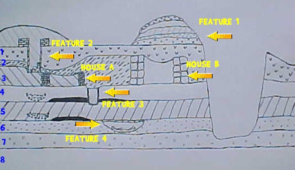
A table below the site stratigraphic profile provides a key to the stratigraphic profile. Each strata/layer is assigned a number shown on the right side of the profile in blue, with the uppermost strata/layer receiving the designation 1, the next 2, and so on. The key notes the presence of a "midden": a midden is an archaeological term for a discrete prehistoric refuse deposit. You can assume that nobody occupied this site until after the glacial till deposit in layer 8 (till refers to the rocks dragged along beneath glaciers in regions covered by icecaps).
The profile includes four depositional units labeled as features. Features are deposits that are unique in the profile and are formed through atypical cultural (i.e., human) processes. They include a soil mound (feature 1), a burial (feature 2), a storage pit (feature 3), and a second burial (feature 4). Each has been assigned a feature number that is indicated in yellow directly above an arrow pointing to the feature. Two houses are also contained in the profile; they are designated House A and House B.
|
|
| Key
Feature 1: mound of soil on site's surface House A: mud-brick structure |
Layer 1: loose dark soil
|
Instructions
Answer each of the following questions individually; be specific, clear, and concise. Type your answers on a separate page; do not attempt to wedge your answers along the margins of the profile. The exercise is due Wednesday, September 26. It can be turned in to me or placed in my mailbox any time prior to that. Late exercises will be penalized a letter grade each day.
1. Identify an example of an unconformity (i.e., provide its strata/layer number). Precisely what unusual natural process formed this unconformity?
2. Identify an example of filling by its feature number. What appears to have been the functional reason for filling this feature?
3. Which of the two households used Feature 3? What material and stratigraphic evidence supports your conclusion?
4. How was Feature 1 formed?
5. To what layer does Feature 4 belong? How do you know this?
 Questions?
Email Dr. Mullins Questions?
Email Dr. Mullins |