|
| Excavations
at 800 Camp Street: Historical Background This year the IUPUI Archaeology Field School will conduct excavations at 800 Camp Street. In cooperation with the owners, the Ransom Place Neighborhood Association, the field school will excavate the now-empty lot at the corner of Camp and St. Clair Streets. The lot contained a stone structure and several small outbuildings by 1887, when it neighbored a home that was probably built about the same time. Today a home stands at 806 Camp Street that appears to be this neighboring structure in somewhat modified form, but the structures at 800 Camp Street were all removed by about 1960. Oral history indicates that the building at 800 Camp was best-known as a store. In 1920, 806 Camp Street was the residence of Martha Miller's household. Miller had immigrated to the US in 1910 from Canada, and when the census-keeper visited her home in 1920 she was recorded as a Black 44 year-old who was running a grocery, which likely was in the corner lot. Neighbors today remember the lot being used as a corner store until around 1960. |
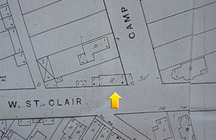 |
| In 1887, the Sanborn Insurance Company's maps recorded a stone structure at the corner of Camp and St. Clair Streets (click on thumbnail above for larger image). The structure's initial uses are unknown, but by 1920 it was apparently used as a store and would continue to be a corner store until it was razed in the 1960s. |
| Today the lot is being readied for
landscaping that will be done by the Neighborhood Association in
June. As the summer progresses, we will regularly report on findings from the
excavations and research, and by summer's end we expect to provide pictures of the new landscape.
This section of the page provides some initial background on the property
as we think ahead to beginning excavation in May. |
The lot as it looks today, facing west across Camp Street. | 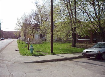 |
| 800 Camp Street's History Like many folks who lived in the near-Westside, we know relatively little about the many people who lived at this south end of Camp Street, but we can piece together some basic information now and will certainly learn more as research progresses. In 1880, the lowest numbered house on the west side of Camp Street (which appears to have been the structure now numbered 806) was the home to the family of steer-driver Daniel Birney and his wife Harriet. In 1880, many of the neighborhood's residents were first-generation Hoosiers, such as the Indiana-born Harriet, whose father and mother were born in New York and Ohio respectively. Thirty-six year-old David was also born in Indiana, but his father was born in Ireland, and his closest neighbor on the west side of the street was a real estate agent whose parents were born in Wales. All of Camp Street's residents were classed as White in the census, and most were native Hoosiers, but like Daniel Birney many of their parents hailed from places outside the US, including Ireland, England, Wales, Canada, and Lorraine (now northeastern France). American-born Camp Street residents came from states including Mississippi, Kentucky, New York, Virginia, Massachusetts, and Ohio, reflecting the mobility of many late-nineteenth-century Midwesterners. The street's residents worked in a wide range of occupations including real estate agents, grocers, painters, stone cutters, domestic laborers, shirt makers, butchers, and shoemakers. Within the six blocks that are today the Historic District's boundaries (10th Street to the North, Martin Luther King to the east, St. Clair to the south, and Paca to the west), the census-keeper recorded 91 households at separate addresses; eight heads of household were Black, and one was classed as Mulatto. |
||
|
|
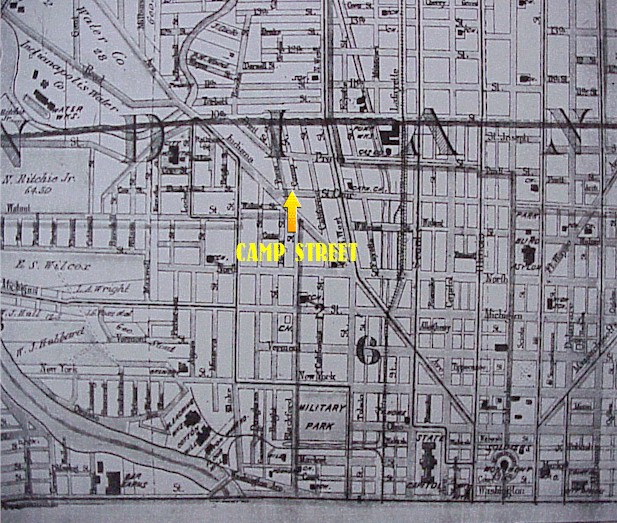
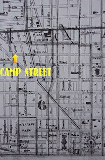
The 800 Camp Street site appears at the arrows in these two copies of the same turn-of-the-century map; click on the map on the left for a broad swath of the near-Westside, including the space where IUPUI is today, and click on the map on the right for a view from Monument Circle up Indiana Avenue. On the map on the right, familiar landmarks like the State Capitol and Monument Circle are at the bottom right (i.e., southeastern) corner. Indiana Avenue, the central thoroughfare in the near-Westside, runs from Monument Circle northwest toward Camp Street and Ransom Place. The map to the left includes near-Westside streets, residences, and businesses that now lay under the IUPUI campus. Note Military Park, which still sits on the south side of New York Street between the campus and the canal. |
 |
|
Early twentieth-century Camp Street In 1900 the census found the family of machine hand Charles A. Doolittle and wife Mary at 806 Camp Street, the first home on the west side of Camp. Mary was born in Indiana in 1860, and her parents were both born in Germany. Her 71 year-old father, meat dealer John Snyder, had immigrated to the US in 1846 and was living with his daughter and son-in-law in 1900. The Doolittles' daughter Bertha was a milliner, son Charles was an offbearer for a printing company, and 11 year-old Agnes was still in school. The majority of their neighbors appeared in the census as White, but Camp Street included two Black households at 832 (the Puryears, who ran a moving business) and 820 (the Sanders, who also had a live-in Black servant). |
||
| The neighborhood became predominately African American in the first decade of the twentieth century. The south end of Camp Street was typical of this transformation. Historically the 800 Camp Street lot has been associated with H.L. Sanders as its earliest African-American resident around 1910. In 1910 the census recorded the family of 23-year-old Black widow Susan Neely at 806 Camp Street. Like the Birneys and Doolittles before her, Neely was a renter. She had been born in Kentucky, as was her sole resident, 16 year-old brother Arthur, who was a tailor working out of their home. The transformation to a predominately African-American neighborhood had been quite rapid: the Neely's 1910 neighbors at 808, 810, 812, 814, 816, 820, and 830 were all Black households, including just one White household on the west side of Camp Street (at 824). | 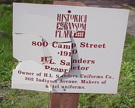 Historically 800 Camp Street's first African-American resident has been identified as H.L. Sanders. The 1910 city directory listed Sanders' home address as 820 Camp Street, and his Indiana Avenue store sold "Gents' Furnishings ... Barbers' Coats, Cooks' and Waiters' Outfits, Butcher Aprons', etc." |
| Martha Miller was a single 44 year-old renter listed as the head of household at 806 Camp Street in 1920. Miller had immigrated to the US from Canada ten years earlier, where both her parents were born as well. While the history of the family is presently unknown, her parents certainly were born prior to Emancipation, so they may have been descended from African Americans who had left the US during slavery. She was identified as a grocery proprietor on her "own account" (i.e., self-employed), and the 1920 Polk city directory listed her as a grocer at 806, so it is likely she was using the 800 Camp Street building as her place of business. Miller's 1920 boarders included two married couples from Kentucky and a Kentucky-born widow, Anna Poole, who was apparently the mother to one of the wives. Both men, Charles Wyatt and Wills Leach, had their occupation recorded as moulders in a foundry. Poole was listed in the 1920 Polk city directory at 806 1/2 Camp Street, so the home may have been subdivided in some form, even though the census recorded Poole, Miller, and the two couples as one household at the same residence. Like many African-American women, the 53-year-old Poole was doing domestic labor. |
Consumption in Ransom Place
By 1920 a community of social institutions, businesses, and workplaces was
springing up alongside the Ransom Place neighborhood in the near-Westside.
By 1920, African-American entrepreneurs were working as undertakers, cleaners,
movers, masons, and grocers in the area that is now the Historic District, and a
walk to Indiana Avenue would have provided many more businesses and social
venues ranging from churches to clubs. Ransom Place itself always remained
predominately residential, though numerous residents worked from their homes in trades such as hairdressers, peddlers,
barbers, cooks, and domestic labor; such labors often are not accorded the status of
"businesses," despite their profound social and material significance.
In 1951, the area that is today the Historic District embraced 254 lots,
according to the city directory, with only seven lots vacant. Of these
lots, two were then groceries, two were churches, and two were funeral
parlors, with several others possibly being businesses operated from the
home. 806 Camp Street was then the home of Jesse Robinson's household, and
the neighbor at 812 was the household of Otis S. Coleman. Yet by the 1950s
the neighborhood was beginning to crumble as the business community, social
networks, and residences in the near-Westside were swallowed up by expansion
from the neighboring hospital and eventually the local university. By 1960
the neighborhood included ten businesses, but a larger number of vacant
residences presaged the neighborhood's rapid decline in the 1960s. By
1970, 74 of the neighborhood's 166 residences were vacant.
In 1960 the city directory did not include a listing for either a household or
vacancy at 800 or 806 Camp Street; the first even-numbered home was the
residence of Mrs. Gladys Coleman. Mrs. Coleman was the first resident
listed on that side of Camp Street a decade later as well.
The summer's excavation goals are foremost simply to establish the project by finding ways archaeology can contribute to community history and the ongoing preservation efforts of the Ransom Place Neighborhood Association. This excavation will provide students and community volunteers an opportunity to learn excavation technique in a quite vital and challenging public setting, and it will of course provide some of our first excavated material culture.
One of our central research interests is in the growth of African-American business and entrepreneurship after the turn of the century, so studying a small business in a predominately residential neighborhood provides an insight into one of the most common African-American enterprises, the corner grocery store. W.E.B. Du Bois noted in his 1898 study of Farmville, Virginia and his celebrated Philadelphia study a year later that groceries were among the most common African-American businesses. In his ambitious Philadelphia study, Du Bois found that only restaurants and barbers were more common businesses in Philadelphia's densely populated Seventh Ward. Many African-American businesses once lined Indiana Avenue, but subsequent development has robbed us of the chance to study these businesses archaeologically. Fortunately, Ransom Place remains relatively well-preserved, so it makes sense to examine one of the groceries or other small enterprises in the neighborhood. Focusing on a modest business managed by an African American in the face of overwhelming material, social, and racist obstacles will begin to provide us a picture of how African-American folks in Ransom Place saw themselves as full Americans who deserved the rights and aspirations accorded any citizen. Sites like 800 Camp Street should begin to give us a sense of how such men and women demonstrated their suitability to full citizenship while delivering a subtle yet profound critique of the notion that citizen rights--from voting to public safety to the right to work, earn, shop, and sell--were reserved for White people.
Portions of this initial historical research were conducted by Susan Sutton's Spring 2000 Urban Anthropology class. For questions on the class' research, contact Dr. Sutton at ssutton@iupui.edu.
| Do you have comments? Corrections? Suggestions? Do you want to contribute to the project as an excavator, oral historical source, or in some other role? Please email me at paulmull@iupui.edu and let me know, or call at 317-274-9847. |
|
|
 |