![]()
| In Summer 2001 the Ransom Place Archaeology Field School will excavate the Evans-Deschler Site, the location of a turn-of-the-century African-American boarding house and a German-managed butcher shop. The home and business sat alongside each other for about 20 years from the 1890's, and the surrounding neighborhood continued to be a home to African Americans into the 1960's. The near-Westside neighborhoods that included Ransom Place are most closely associated with their African-American residents, but in the late-nineteenth and early twentieth centuries the community west of the Canal was quite multicultural: Germans, Irish, and English immigrants lived alongside African Americans and White Hoosiers well into the twentieth century in many near-Westside neighborhoods. This summer's field school will examine a site that included both African-American and German residents, a project that will help us further understand cultural complexity in these neighborhoods. | Page links
|
The Evans-Deschler site is located south of Indiana Avenue and outside the boundaries of the Ransom Place Historic District. Unlike the well-preserved Ransom Place neighborhood, the thousands of homes that lay south of Indiana Avenue have all been razed and only survive as archaeological sites, mostly underneath IUPUI parking lots and campus spaces. This summer the university will continue a major renovation project in the four blocks bordered by West, Michigan, Blackford, and New York Streets, an area that is now home to the new Law School building at the northwest corner of New York and West Streets. The construction of new buildings and landscaping in this area informally known as the "Super Block" will destroy many of the archaeological deposits in this area, so this year's field school will conduct its excavations here prior to late-Summer and Fall construction.
"Super Block" Historical Background
| Divided into lots around the mid-nineteenth century, the Super Block likely was among the first IUPUI campus spaces to be settled by Europeans. West Street is the western border of the original "Mile Square" plan created in 1821 by Alexander Ralston. An 1831 map of the city (right) identifies the Military Park lot immediately south of the Super Block as a "reserve," and it shows New York Street extended west to a dead-end conclusion at about where Blackford Street is today. Michigan and Vermont Streets each ended at West in the 1831 map, and neither California nor Blackford Streets had been laid out at that point. The map does not show any structural features, but it does identify a steam mill on the White River, and a market square appears in the plan at the northeast corner of West and Market Streets. | 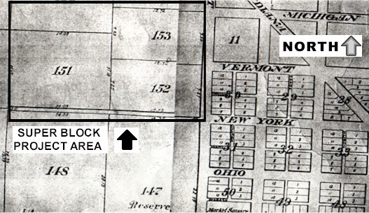
This 1831 map (above) shows the western edge of Indianapolis' central "Mile Square" plan, which neighbors the Super Block project area. The square marked "Reserve" just south of the project area is Military Park. |
The Super Block is located immediately north of Military Park, which is bordered by New York Street, West Street, Blackford Street, and the Central Canal. The oldest public park in Indianapolis, Military Park was donated to the State by Congress in 1827, and it was originally used for militia training. The Park was the site of Indianapolis’ first recorded Fourth of July Celebration in 1822, and in 1852 it hosted Indiana’s first State Fair. During the Civil War, it was a camp for recruitment and training, and thousands of soldiers encamped there, when it was known as Camp Sullivan. The Park was decorated with a fountain and Civil War relics in the late-nineteenth century, and between 1908 and 1916 a pavilion was erected that still stands.
The Central Canal was built to the east and south of the project area between 1836 and 1839, and some industries soon began business nearby, such as the Sheets paper mill at Market and West Streets, and a flour and wool mill along the White River. The emergence of these industries encouraged residents to move toward the western edges of the Mile Square, which by mid-century became densely settled. Some of these newcomers arrived via improved transportation networks that ran through Indianapolis. The National Road, the main east-west highway in the antebellum US, extended through Indianapolis in the 1830's, and in 1839 the central north-south road in the region, Michigan Road, crossed at Washington Street and passed north directly to the east of the Super Block. These overland routes brought many migrants to the Circle City from Ohio and Kentucky, and by the final quarter of the nineteenth century both states were well-represented by residents in the project area. Near-Westside residents found an increasing amount of industrial employment in walking distance. No heavy industries ever were located in the Super Block, but flour mills, pork slaughtering and packing houses, foundries, and railroad yards were located in walking distance. Indianapolis’ manufacturing expanded rapidly after the arrival of the railroad in 1847, and the city's population doubled over the 1850's and again over the 1860's, reflecting the growth of local workplaces and Indianapolis' increasing accessibility.
| The Super Block had taken the basic form it has today by the mid-1850's, and its first residents settled along New York Street in the early 1850's. By the 1880's the lot property lines and alley layout were clearly defined. Ten-foot wide unpaved alleys that are no longer extant ran through the blocks. Most of these alleys had street names and eventually hosted small homes, but they were too narrow for significant traffic. At various times, smaller un-named alleys as narrow as 5' wide also were cut through portions of the block to access stables, backyard workshops, businesses, and modest homes. | 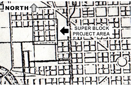
By the time of this 1855 map (above), the project area was divided into lots. |
In the late nineteenth century the neighborhood that now rests under the IUPUI campus was a relatively compact residential community within reach of railroad yards in West Indianapolis, packing houses (with the largest to the south), and various city workplaces. The 1887 Sanborn Fire Insurance map indicates that the project area’s homes were primarily frame one and two-story structures, with no businesses, churches, or other non-residential spaces identified. A few modest enterprises eventually set up shop in the Super Block: for instance, the Century Biscuit Company sat at the corner of New York and Blackford Streets between 1908 and 1914, and a sanitarium was accepting visitors at 538 New York Street, at the northeast corner of New York and California. Some residences also hosted home-based businesses (e.g., laundresses, seamstresses, etc), but the neighborhood always remained predominately residential.
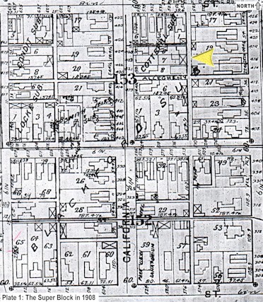 |
In 1908 (left), the project area was completely covered in residences. Michigan Street runs along the top of this map: if you enter the IUPUI campus from West Street you drive by this neighborhood to your left, though most of it is today covered with parking lots. The 2001 Field School site is just east of California Street, at the yellow arrow on this map. |
At least two churches have called the neighborhood home since the late nineteenth century. The Merritt Place Methodist Episcopal church was established at the northwest corner of New York and California between 1914 and 1916, apparently in a remodeled home that had stood in the lot at the turn of the century. The congregation remained there until at least 1935. By 1935 the Sanctified Church of God was located at 419 California Street, in a 1½ story stove-heated frame building less than 30' square. Several other churches were located in blocks neighboring the Super Block. The best-known of these, Bethel African-Methodist-Episcopal Church, was established as a congregation in 1836 and active in the abolitionist movement and the Underground Railroad. The church was burnt in 1862, apparently by slavery supporters, and in 1867 the church was rebuilt where it still stands at 414 West Vermont Street, just a block east of the Evans-Deschler Site.
The first clear demographic profile of the neighborhood comes from the 1880 census. When the census-keeper recorded the homes within the Super Block in 1880, they identified 251 residents, of whom nearly half (122) were native-born Hoosiers. Over one-quarter (27%) were foreign-born, including immigrants from Ireland, Germany, Scotland, England, and Canada, but just 11 individuals were identified as Black or Mulatto. After Indiana, the most common birthplace of neighborhood residents was Ohio (21), Pennsylvania (18), Kentucky (17), Ireland (16) and New York (11). Only two families in the project area had Black or Mulatto heads of household in 1880, and the remaining two people of color were employed as live-in domestics. One of these two African-American live-in domestics, Lily Carson, was working in the household of David Cady at 235 California Street, on the site that this summer's field school will excavate.
By the early twentieth century, the community west of the downtown canal became home to many African Americans. These residents were part of the Great Migration fleeing Jim Crow racism and searching for improved material and social opportunities in the north and Midwest. Settlement patterns in the Ransom Place neighborhood indicate that the blocks surrounding Indiana Avenue were settled by African Americans more quickly than the Super Block. In 1910, 469 of Ransom Place’s 707 residents were Black or Mulatto (66.4%). In contrast, the Super Block had just 13 Black or Mulatto residents among the 638 individuals living on the block (2.03%). The Super Block was still thoroughly White Hoosier: nearly two-thirds of the Super Block’s 638 residents in 1910 were born in Indiana, and 13.32% (85) were born outside the US. The most common birthplace of Super Block residents born outside the US in 1910 was Ireland (25), with a range of Eastern European neighbors from Austria, Germany, and Hungary. The Super Block also included Yiddish neighbors from Russia, Austria, and Germany (14 total). It appears that in the 1920's the Super Block was making the transition to being a predominately African-American neighborhood, a process that had happened along Indiana Avenue and in neighborhoods like Ransom Place a little more than a decade earlier.
Some of the Super Block’s lots began to be subdivided into rental residences in the late-nineteenth century, which increased landlords' earning potential. This pattern was typical throughout the near-Westside. In 1900, for example, 22 of 36 properties on the block between Vermont, California, Michigan, and West were rentals. In comparison, 64.1% of the properties in Ransom Place in 1900 were rented; ten years later in 1910 the percentage of renters in Ransom Place would mushroom to 77.8%. Many small homes on narrow or half lots were built backward as far as the lot would accommodate, yielding quite cramped quarters.
Steinmetz and Deschler Meat Packing Site
Indianapolis hosted pork-packing operations since the 1830's, and by the 1880's it was the third-largest pork-packing city in the world behind regional neighbors Chicago and Cincinnati: in the early 1890's, over a million pigs, cattle, and sheep met their end in Indianapolis' stockyards every year. Many of these operations were relatively modest in scale, but one of the nation's largest meat-packing firms, Kingan and Company, was located at Maryland and Blackford Street between 1862 and 1966.
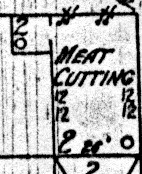 |
One of Indianapolis' modest-sized meat packing enterprises was located in the backyard of a home along California Street. In 1898 (left), the home behind 423 California Street had an outbuilding marked "Meat Cutting." The neighboring home was owned by John and Helena Deschler, both of whom had immigrated from Germany in 1860. John was described in the city directory as a meat dealer, as was his 30-year old son John Jr. and son-in-law Charles Knuzer. Ten years later, in 1910, son John Jr. was renting the neighboring home along with his brother-in-law, both of whom appeared in the census as butchers. |
The 1914 Sanborn map identified the building as the "Steinmetz Packing Co./Meat Cutting and Packing," so the Deschlers apparently had a partner. In 1900, Jacob L. Steinmetz and brother Edwin were identified as proprietors of a meat market in the city's Market House. In 1914, the city directory listed the Steinmetzs as having a shop at the California Street site as well as in the Market house; apparently the California Street shop was preparing meats for sale in the Market House. The California Street shop apparently had closed by 1919, and all the structures associated with it were torn down after 1927.
The Deschlers' entrepreneurial path is relatively typical of many European and African-American newcomers alike. The elder Deschler was operating a Market house stall in the 1880's, an operation with relatively modest cost that could eventually provide sufficient funds for his family to purchase and run their own store. In 1890 the Deschler family was running a grocery at their home at 151 Agnes Street (now University Boulevard), where the University Conference Center sits today. Groceries, though, were the most common business in late-nineteenth century Indianapolis, and their failure rate was quite high; by the time the Deschlers moved to California Street in the late 1890's, they apparently abandoned the grocery, focused wholly on meats, and returned to selling from the City Market stall. Many of the Deschlers' German neighbors also launched businesses: in 1875, for instance, 91 German-American enterprises sat on the three blocks of Washington Street between Illinois and Delaware Streets.
Indianapolis had a quite sizable German immigrant population: in 1890, 18% of the city's population was of German ancestry. However, they came from a vast range of cultural, religious, and generational backgrounds, so they were far from a monolithic group. The Deschlers arrived in the US in 1860 between two major waves of German immigration. The generation of Germans that arrived in Indiana following the Revolution of 1848 into the Civil War included many well-educated middle-class liberals, and their arrival coincided with an explosion of the German-language press and social clubs in the city. These arrivals were strong abolitionists and Union supporters during the Civil War, since many were still stung by the failure of Germany's republican movement in 1848. After 1870 into the 1890's, another wave of Germans began arriving in Indianapolis. This next wave was primarily from eastern Germany and tended to be mostly manual laborers.
 This summer's project at the Steinmetz and Deschler meat
packing firm will provide us initial insight into German-American life and
entrepreneurship in the
near-Westside. Like their African-American neighbors, residents of German
ancestry were subject to racism and cultural xenophobia, but it was quite
different from anti-Black racism. We are interested in how the specific
boundaries erected before German Americans were negotiated, and we are
interested in their relationship with neighbors like the African-American
boarders who lived within 3' of the Steinmetz and Deschler meat packing establishment on California
Street. This summer's project at the Steinmetz and Deschler meat
packing firm will provide us initial insight into German-American life and
entrepreneurship in the
near-Westside. Like their African-American neighbors, residents of German
ancestry were subject to racism and cultural xenophobia, but it was quite
different from anti-Black racism. We are interested in how the specific
boundaries erected before German Americans were negotiated, and we are
interested in their relationship with neighbors like the African-American
boarders who lived within 3' of the Steinmetz and Deschler meat packing establishment on California
Street. |
The lot neighboring the meat packing firm was divided in half between 1900 and 1908. In 1900, only a house fronting California Street sat on the lot, when it was the residence of African Americans Albert and Lillie Henderson and their five Black lodgers. Between 1900 and 1908, a single-household residence was built at the rear of the lot along the Johnson Street alley, immediately neighboring Steinmetz meats: the wall of the home was about three feet from the meat-packing firm. In 1910, the home at the rear of the lot was the residence of Hattie Evans and four lodgers. Evans and her lodgers in 1910 labored at many of the most common African-American occupations. For instance, the 64-year old Evans and lodger Edna Jones were laundresses for private families; they may have done laundry in the yard space on California Street, as well as in the homes of White employers. Fellow lodger Belle Thompson was a domestic, John Curry was a janitor in an office building, and Richard Bowling was a cook in a cafe. These sorts of manual labor positions--often working in White homes and workplaces--were common to many African Americans throughout the near-Westside.
Evans’ household was one of only three African-American households in the Super Block in 1910. Like many neighbors in the ensuing half-century, the residents moved often. By 1914 Evans was no longer living in the home, and the heads of household were Wesley L. Lockridge and Belle Thompson. Lockridge, who drove an ash wagon, remained at the California Street home into the 1920's, but most of the boarders sharing the home stayed for very short periods and sometimes moved to other addresses in the near-Westside. In 1920, the tiny building at the rear of 423-425 California Street was home to 14 African Americans, an astounding number of people for such a small home. The density of residents was an indication of how densely populated much of the near-Westside was becoming on the eve of the Depression.
| In 1914 (right), a Sanborn Insurance map made this record of the Steinmetz Packing Company and the Evans boarding flat just south of it. The meat-packing firm had moved by 1919, but some buildings associated with it remained standing until at least 1927. The modest home at the rear of 423-425 California Street also appeared on maps for the last time in 1927 and had been torn down by 1941. The space remained as backyards for California Street homes into the 1960's, and today it is a gravel-covered parking lot. | 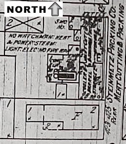 |
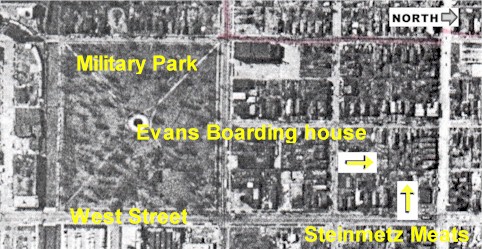 |
This aerial view (left) was taken in the 1960's, prior to demolition of the homes. Most of the streets remain in the same place today, but now the blocks north of Military Park (the right side of this picture) are mostly parking lots. |
All field excavation at the Evans-Deschler Site is conducted by students enrolled in the IUPUI Archaeology Field School, which we offer each Summer somewhere in the near-Westside. The Archaeology Field School (Anthropology P405) is open to any undergraduate student for four to six credits. You do not need to be an Anthropology student or have any archaeological coursework or experience to enroll in the course. Students are trained in field excavation methodology, public interpretation, laboratory analysis, and archaeological theory. Students learn to identify nineteenth- and twentieth-century material culture, excavate historic-period urban sites, and work actively with many visitors and our partners in the Ransom Place Neighborhood Association. For registration details, enrolled IUPUI students can contact the Registrar's Office or visit Insite. Visiting students can get details on credit transfer on the Registrar's Visiting Students page. For details on the class schedule, visit the course syllabus.
Volunteers are welcome to work alongside field school students after May 21st. You can volunteer for as many days as you like; we prefer to have volunteers call ahead, and it works best to spend a whole or nearly whole excavation day on site. Volunteers younger than 16 should be accompanied by a parent or adult. If you would like to volunteer but do not want to dig, we will also maintain our lab during the field season in Cavanaugh Hall, where recently excavated artifacts will be washed as they come in from the field. If you would like to volunteer over the summer or have questions, please email Paul Mullins (paulmull@iupui.edu) or call (274-9847) for details.
For ongoing reports on the field excavations, check here over the Summer. For field school reports, visit the May 14, May 27 or June 16 Field School Reports.
 |
 |