
|
|
|
|
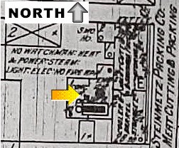
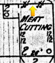
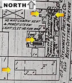
The 2001 Field School has now opened a handful of units across the site, and most are clearly in demolition deposits associated with the circa 1930 destruction of the Deschler meat packing shop and the Evans boarding house. This 1914 Sanborn map to the left shows where several units have been placed to this point; click on any of the arrows or just scroll down this page to look at these units and the artifacts that have been recovered from them so far. |
 Around
the turn of the century the Deschlers extended their original structure to
the south and west, into what had been back yard space prior to that
time. The single-story extension to the west (at the arrow on the
1914 map to the right) housed a 14 horsepower engine that was used to
prepare meat cuts. Around
the turn of the century the Deschlers extended their original structure to
the south and west, into what had been back yard space prior to that
time. The single-story extension to the west (at the arrow on the
1914 map to the right) housed a 14 horsepower engine that was used to
prepare meat cuts.
We placed a three-foot wide (east-west) by ten-foot long trench along the center of this structure, which had a concrete floor and laid brick surfaces already partially exposed by the bulldozer. The area roughly around the engine in this map included very dark soil, and the concrete surface underneath this spot have collapsed downward.
|
|
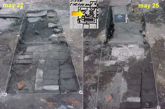 In
the thumbnail to the left, the trench appears to rest along the eastern
edge of the shop's addition. In the May 22 picture, the spot where
the engine appears to have sat is in the dark soil at the top of the
picture. When that soil was removed by May 25, the partially
collapsed concrete floor was revealed. In
the thumbnail to the left, the trench appears to rest along the eastern
edge of the shop's addition. In the May 22 picture, the spot where
the engine appears to have sat is in the dark soil at the top of the
picture. When that soil was removed by May 25, the partially
collapsed concrete floor was revealed. |
|
| Deposits over the addition's concrete floor contained several pieces of costume jewelry that likely dates to the period between about 1920 and 1940, including the Knight of Pythias pin shown in the May 14 field school report. Unfortunately, it is hard to say who discarded these items: they may have been thrown away by the people who lived in California Street homes after 1930, or they could be associated with the last residents of the neighboring Evans boarding house in the late-1920's. They likely were discarded after World War I, when the Deschlers stopped working at the site. Excavating around this trench will hopefully allow us to date these deposits more precisely and help determine which of the surrounding households most likely discarded these artifacts. | 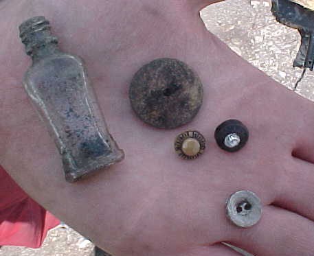 This
handful of buttons and a perfume bottle (left) are typical of the personal material goods found in this trench. This
handful of buttons and a perfume bottle (left) are typical of the personal material goods found in this trench. |
 Right:
This now-empty compact probably once
held cosmetics. Right:
This now-empty compact probably once
held cosmetics. |
|
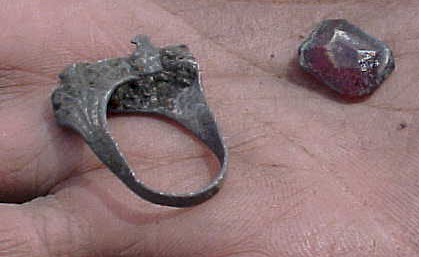
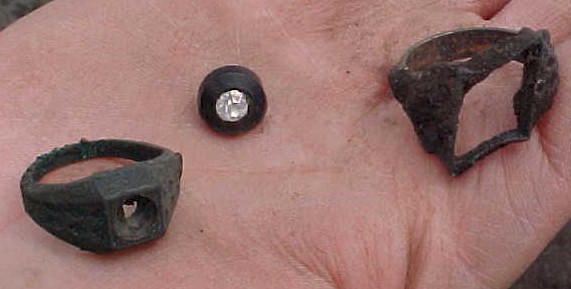 Left:
These two rings now missing their stones and a button were among the
costume jewelry found in the trench. Left:
These two rings now missing their stones and a button were among the
costume jewelry found in the trench. |
|
| In
1887 an outbuilding sat in the northeast corner of the site where the
meat-packing shop would soon sit, but the structure's function was
unidentified in the 1887 map. By 1898 (near right), the outbuilding
was identified as the Deschlers' meat-packing shop.
A four-course wide brick foundation for the northern wall was uncovered by the bulldozer when the site was cleared. A unit was placed along this wall, which by 1914 was the location of a kettle that was likely being used in sausage manufacturing. We placed an excavation unit along this wall to determine when the structure was built or modified and to see what evidence of the shop's operation survived archaeologically along this wall. To this point we haven't yet excavated through a dense demolition layer that is composed of bricks and scattered artifacts that extend a foot beneath the surface so far. |
 |
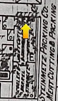 |
| Above: A unit was placed along the northern wall of the shop at the arrow in this 1898 Sanborn map. | Above: In 1914, the Sanborn map showed a kettle along the north wall in the same location. |
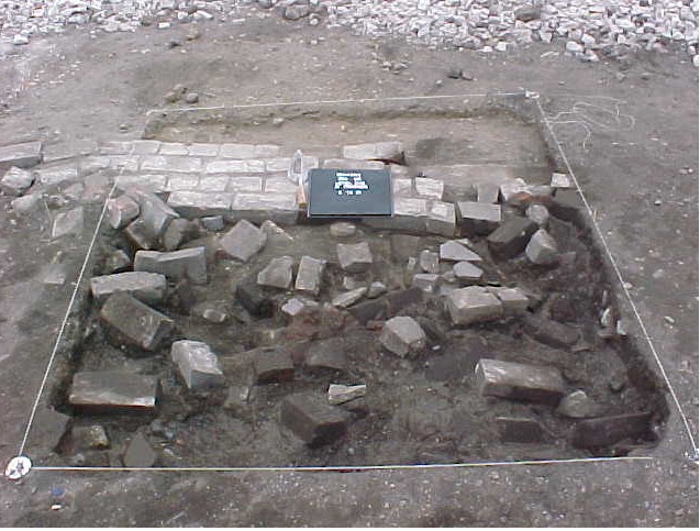 |
Left: This May 22 picture shows the demolition layer that appeared immediately below the present ground surface. | 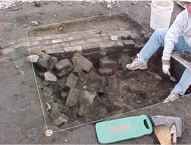 |
Left: Several days later the rubble level still continues across the base of this unit. |
| What did this unit look like a week later? Check the June 6 picture. Use your browser's back arrow to return to this page. |
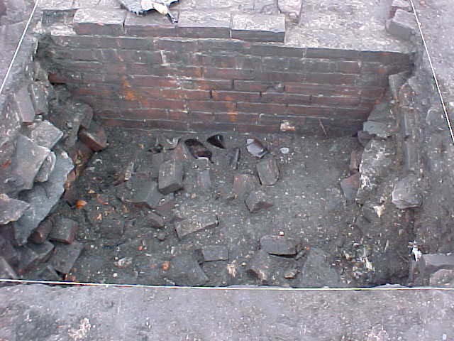
Deschler Shop Northwest Corner
| The northwest corner of the Deschler shop is in the same spot on all the available maps of the building, so if we can date when this corner was constructed we can firmly date the building. The corner was a small room just west of the kettle in 1914, but the space's function is unknown. Because the space is filled with a dense deposit of coal, it may have been intended to store coal used in shop machinery. |  Right:
In 1914 the northwest corner of the shop sat just at the arrow in this
picture. The precise function of this room on the corner of the
building is unknown. Right:
In 1914 the northwest corner of the shop sat just at the arrow in this
picture. The precise function of this room on the corner of the
building is unknown. |
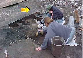 In
this thumbnail left, the arrow is placed directly at the corner of the
shop; Rachel (with the hat) is sitting on the north wall. In
this thumbnail left, the arrow is placed directly at the corner of the
shop; Rachel (with the hat) is sitting on the north wall. |
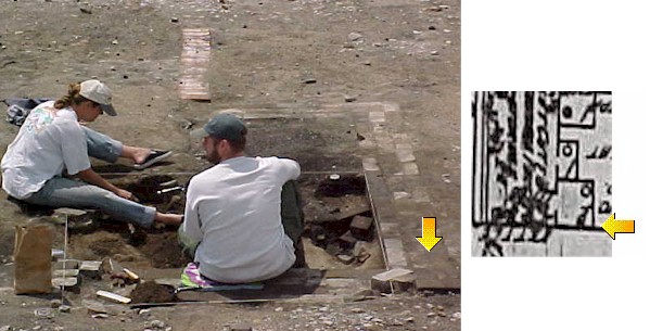 The
thumbnail left shows the unit facing south. The arrow is placed at
the corner of the structure in the 1914 map and the dig picture.
You'll notice the brick line of the foundation, which runs in a line like
that in the map. The
thumbnail left shows the unit facing south. The arrow is placed at
the corner of the structure in the 1914 map and the dig picture.
You'll notice the brick line of the foundation, which runs in a line like
that in the map. |
|
|
One of our initial units is associated with the Evans Boarding House, shown left in the 1914 Sanborn map. Some two-course wide brick foundations have been identified for this structure's northern wall (i.e., along the top of this 1914 map top left), but the bulldozer identified fewer structural features here than in the neighboring Deschler shop, so we were not even sure yet whether the unit is within or outside the structure. However, the thumbnail at bottom left (facing south) shows a line of bricks that are probably the north wall of the boarding house; this makes it appear that the unit is inside the very western end of the boarding house. |
|
|
 Left
(thumbnail): This ring and costume jewelry stone were among the artifacts
found near the surface of the unit. Left
(thumbnail): This ring and costume jewelry stone were among the artifacts
found near the surface of the unit. |
The unit has contained a dense collection of small fragmented objects mixed in demolition debris, like broken bricks and mortar pockets. As with other units on the site, we expect to excavate beneath this demolition level to ground surfaces that date to the period when the site was being used as a boarding house and meat packing shop. |
If you would like to visit the site, we will be digging on all sunny weekdays from 9:00-3:00 through June 20th, so just drop by anytime.
For more background on the site and its residents, visit the Evans-Deschler Field School page. To visit the first installment in the field school journal, return to the May 14 Field School report.
For more on the summer's excavations, check the June 16 Field School Report.
|
|
|
|

