|
|
Between 1908 and his death in 1920, Indianapolis native Christian Schrader drew pictures of Indianapolis as he remembered the city from his childhood. The self-taught artist grew up in Indianapolis at the middle of the nineteenth century, and as an adult he made his livelihood running a china shop on Washington Street. When he retired in 1908, he began penning his memories of the city as it was a half-century before.
| Schrader's drawings of the city include almost nothing on the western side of West Street, where IUPUI sits today, and there is no reason to doubt Schrader's recollection. In 1850, Indianapolis was a rather small and undistinguished town, but it was on the brink of rapid population growth: the arrival of railroads, the establishment of the National Road (i.e., Washington Street), and the expansion of local industries, such as pork packing, would soon contribute to the city's rapid growth. Schrader's most detailed map of the area showed Military Park and New York Street running along the north side of the Park, however he placed only one house along New York Street (where the Law School is today), and none earlier than 1851. | Links on this page |
| In 1855 much of the IUPUI campus along West Street had just recently been divided into lots between New York and North Streets. Along the White River the Mill Race creek meandered through what is now E-lot; people were slow to settle along this swampy flood plain until the twentieth century. The Mill Race was one of many Fall Creek channels that emptied onto campus into the final quarter of the nineteenth century; the 1870 map on this page shows even more unruly Fall Creek channels spilling across the western edges of campus. | 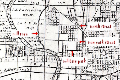 |
When Schrader began drawing maps of the near-Westside before World War I, the area looked quite different than he remembered from his childhood. By the early twentieth century the near-Westside was densely settled and included thousands of homes as well as churches, schools, factories, businesses, and clubs. By 1908, African Americans, European immigrants, and White Hoosiers had densely settled the near-Westside and created a landscape vastly unlike the open spaces and riverside marshes young Christian Schrader witnessed there in the early 1850's.
Today, nearly a century after Schrader's recollections of the city, the near-Westside again looks much different: university buildings, grounds, and parking lots sit alongside a scatter of state buildings, businesses, and apartments. Yet the traces of past landscapes survive archaeologically today across the IUPUI campus; elders have rich memories of these neighborhoods; and a mountain of documents survives awaiting thorough analysis. Ransom Place Archaeology is currently conducting an archival survey of the neighborhoods that once covered the IUPUI campus. The project was made possible by an Indiana University Arts and Humanities Initiative Grant, and this support will make it possible to begin to develop a systematic history of the space that is now occupied by IUPUI. This survey will provide reliable documentary information on these neighborhoods and help the community and university manage the heritage beneath campus.
 |
Left: This 1914 Sanborn map shows the first six study areas examined in the campus survey project. Descriptions and locations of each study area can be found by clicking on the shaded boxes. Click on racial composition by neighborhood area between 1880 and 1920 for information on period racial demography in each neighborhood. |
The survey involves no actual archaeological excavations on campus, but the research and assessment of potential archaeological sites will help us develop a systematic policy for how the campus' archaeology can be preserved and documented. Our primary goal is to develop a demographic outline of the community: we want to understand the people, workplaces, and neighborhood institutions that have occupied this space over a century-and-a-half. We are doing this through intensive research in primary records including the census, city directories, and maps. These records will provide information on who lived here, where they came from, when did they migrate here, what did they do when they arrived, and in some cases where they and their descendants went after living here.
Historically the campus neighborhood is most closely associated with the African-American community, which arrived in quite significant numbers in the first decade of the twentieth century as part of the "Great Migration." These newcomers joined African Americans already living in the area, and most newly arrived people of color focused their business, leisure, and residential life on the neighborhoods around Indiana Avenue. However, census research demonstrates that White Hoosiers and European immigrants lived alongside African Americans in many campus neighborhoods well into the twentieth century.
George Pogue is often credited with being the first European to settle what is now Indianapolis; his family's accounts date his arrival to February or March 1819, though in 1854 his widow reportedly dated the Pogues' move to March 1820. At about the same moment--and perhaps even a bit earlier--, brothers John and James McCormick arrived with their families and built cabins on the White River bank near the eastern end of the former Washington Street bridge; this would be along the very southern edges of the present-day IUPUI campus. Among the McCormicks' earliest neighbors was Revolutionary War veteran Isaac Wilson, who settled on April 6, 1820 where the State House sits today; in 1822 he moved from that home to a site on the current Medical Campus. Wilson built a mill along the Mill Race, which ran south from Fall Creek to the White River just west of the settlers’ homes. The mill later was run by Samuel Patterson, who married Wilson's daughter and moved into the Wilson home, which was built in the 1820's.
Epidemic reportedly swept the area in 1821, and the Wilson yard became a burial ground. This "plague burying ground" originally held eight or nine graves; apparently the cemetery was used a modest number of times afterward as well. In 1947 Medical Center historian Thurman Rice said the cemetery was located 100 feet west of the Medical School Building (now known as Emerson Hall) and still had several standing or fallen tombstones at the site in 1947. The burial space was still marked in 1954, roughly where the Van Nuys Medical Science Building sits today along what is now known as Barnhill Drive. Maxwell's frame house proved remarkably resilient: still a residence for Wilson descendants in the early 1920's, the structure apparently was not dismantled until the 1930's.
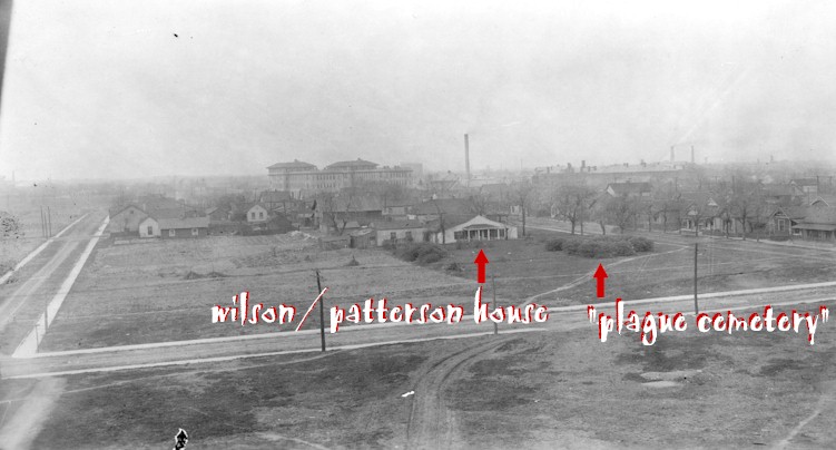 |
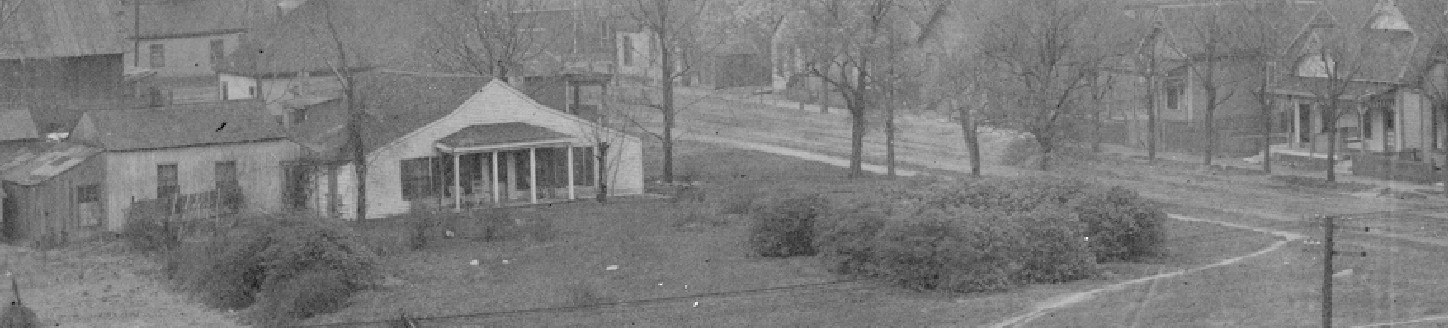
Left: in about 1920 this photograph was taking facing north across North Street in the foreground; the street to the left was Wilson Street, and the street on the right was Maxwell. The likely burial space for the area's earliest settlers was within the clump of the bushes just to the right of the house; see the close-up below (courtesy IUPUI University Library Special Collections and Archives). |
 |
| Indigenous peoples had been in the area for millennia, but none settled on the swampy flood plain along the White River. When Europeans arrived they found similarly uninviting ecological circumstances: swamps and a meandering creek dotted the space that is today campus, and the proximity to the river and neighboring waterways ensured regular flooding. Very few people settled the area that is now campus until the 1850's, and the westernmost portions of the undergraduate campus--such as the E lots on the north side of New York Street--were not settled until early in the twentieth century. In 1870 (right), Fall Creek and its tributaries still spilled unpredictably across the western borders of campus. A series of massive filling episodes in the mid-1870's re-channeled much of Fall Creek directly west to the White River, roughly where it empties into the river above 10th Street today. | 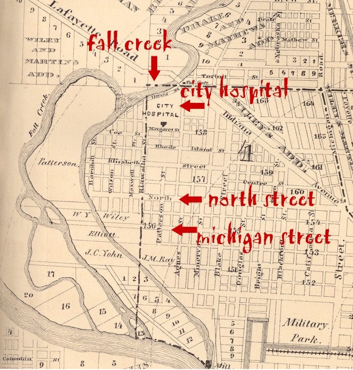 |
In the 1830's and 1840's, historian W.R. Holloway (1870:54) remembered that horse races were held on "the portion of what is now West street, lying north of the `mill race,’ and extending to the Michigan road (Indiana avenue)." Holloway (1870:104) noted that when the City Hospital was built in 1859, where Indiana Avenue crosses Fall Creek, there "was a vast, open, empty common between this location and the city, now almost entirely built up." Despite hosting some of the city’s first settlers, this northwestern portion of the city had become undesirable because of constant flooding and health problems. Fall Creek fanned southward from a location near 10th Street and Indiana Avenue into a number of ill-defined tributaries; subsequent roadways were laid along the same angles as these creeks, including examples such as Beauty Street, which still meanders at an odd angle across E-lot.
|
|
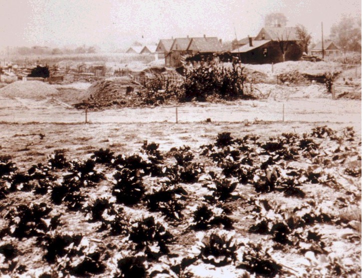
This picture was taken on the current Medical Campus during the initial construction of Riley Hospital in 1922: the foundations in the upper left are the beginnings of Riley Hospital, whose construction began in September 1922. In the foreground--opposite the neighbors' cabbage patch--sat North Street, with houses on Barnhill Street just to the east (right) (picture courtesy Glenn Irwin, from IUPUI University Library Special Collections and Archives). |
In the early twentieth century, roughly 75 storefront businesses were located on campus, including scores of groceries on nearly every corner. In 1914, 50 grocery stores alone occupied almost every corner of campus. A couple open-air theaters eventually followed by nickelodeons made their home on campus, a School of Elocution was located on the north side of New York Street just south of the University Library, and Casper Maus' brewery sat at the northwest corner of New York and Agnes (now University Boulevard), which is now a parking lot. Several large industries were located along the White River, just south of where the Natatorium stands today, including the Indianapolis Bleaching Works and the Acme Evans Flour Mill. Nearby sat Kingan and Company, one of the world's largest pork packing plants. Many campus residents in the neighborhoods now under the Indianapolis Tennis Center worked at Kingan's, especially Irish immigrants who often were attracted to Indianapolis by Kingan's advertising in Ireland. Kingan's also contributed to the distinctive industrial scent that hung over turn-of-the-century Indianapolis: on a warm summer morning a breeze would waft the unpleasant odor of Kingan's and neighboring industries over campus.
| The survey research is contributing to a rich history of the many businesses that once occupied the IUPUI. The Indianapolis Casket Company, for instance, sat on North Street from 1910 until the building was purchased by the Indiana University Foundation in 1984 and demolished a year later. The future casket company structure was built between 1887 and 1898, when it first appears in the city directory as the home of Thomas Potter and Son's hat store. Potter and his son remained on North Street until 1909; Thomas Potter Sr. died in 1910 and the son moved the firm to West Maryland Street. In 1910 the casket company had incorporated and moved from their East Ohio Street location to North Street. In November 1984 the I.U. Foundation purchased the property; today the space is home to parking lot 73 east of Mary Cable and south of Sigma Theta Tau. | 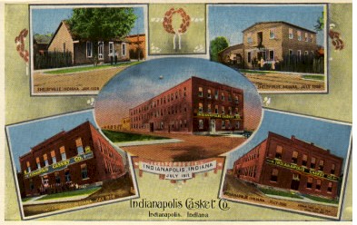 |
|
|
|
Top: A circa 1912 postcard image
of the Indianapolis Casket Company highlighted its North Street home and
its former home in Shelbyville (collection of the author)
Left (thumbnail top): the Casket Company on the 1914 Sanborn Insurance company map. Left (thumbnail bottom): the Casket Company in 1975 (from IUPUI University Library Special Collections and Archives). |
|
 |
||
Pockets of quite genteel residents were located on campus. In African-American areas, schools and churches tended to be home to many of the community's elite residents. One of these areas was the block surrounding School 4, the Black elementary school that stood where the Mary Cable Building is today. The northwest corner of North and Blackford Streets was home to the Jones AME Zion Church, the West Mission AME sat on the west side of Blackford Street between North and Michigan (where the new parking deck sits today), and the California Street AME Church was located at the southeast corner of California and North, just a block away. At the southwest corner of Michigan and Blackford--directly diagonal from Mary Cable, where the Science and Tech Building sits today--sat Fifth Presbyterian, a massive cruciform-shaped church that became the People's Congregational Church between 1890 and 1895. All of these churches were built between 1870 and 1875 and were joined by at least 50 more in the following half-century.
|
|
| The 1975 image above shows a house at 725 West Vermont Street: these residents and their last few neighbors already were engulfed by IUPUI parking lots. Bright Street runs from left to right across this picture, toward the former School of Law on New York Street. The large building in the immediate background was the Century Biscuit Company. The Biscuit factory at the northeast corner of New York and Blackford Streets closed after World War II (from IUPUI University Library Special Collections and Archives). The thumbnail right shows the full original image. |
|
The Color Line in Near-Westside Neighborhoods
The campus survey is designed to provide systematic information on the people who have lived on campus over 150 years and identifying how and why settlement patterns changed over that period. The near-Westside mirrors many of Indianapolis’ predominant demographic patterns, but it still retained considerable diversity across the neighborhoods between the Canal, White River, and 10th Street. Indianapolis is often reduced to an ethnically homogenous city, and in comparison to northern metropolises like Chicago Indianapolis did indeed have many fewer European immigrants. Native White Hoosiers dominate almost all census inventories from the near-Westside until the 1920's or later, but a vast range of European immigrants and African Americans also made their homes throughout the near-Westside. Like much of the city, the near-Westside had considerable neighborhood diversity, with quite distinct ethnic and class settlement patterns that changed over time.
Of the migrants who settled in the near-Westside, African Americans established the clearest long-term presence, especially along Indiana Avenue. However, neighborhoods south of Michigan Street remained home to many White Hoosiers and European immigrants well into the Depression. Many areas that eventually became predominately African American also did not become Black neighborhoods until after the Depression. The popular impression that the near-Westside was a universally Black and poor community over more than a century certainly contradicts the vast social, ethnic, and class diversity attested to in primary literature.
A detailed census analysis was conducted of six near-Westside neighborhood study areas on the IUPUI campus to establish the area’s basic demographic patterns. All census information for the years 1880, 1900, 1910, and 1920 was transcribed for all residents in these six neighborhoods, providing a sample of 7253 residents. (Data from the 1930 census was not released until this project was nearly completed, so it has not yet been integrated into the database.) While the census is not without drawbacks, this sample still provides our best demographic picture of the near-Westside at the turn of the century.
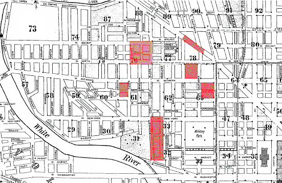
Six neighborhood study areas were selected from the contemporary IUPUI campus. The neighborhood study areas are in most cases single blocks and all homes facing onto them, though the size of these blocks and number of homes within each varies considerably. Homes facing each other within contiguous blocks were considered part of single neighborhood samples; i.e., "neighborhoods" were not defined only as homes inside a single block but instead defined as homes that were both within a block and facing onto it. This methodology assumes that homes that face each other are likely to be of a comparable social and material status, and in many cases they are often more similar than homes that back onto each other. Most of the near-Westside is overwhelmingly residential, spotted with corner stores within neighborhoods, and these neighborhood study areas reflect that pattern. Only one area in the sample, the Indiana Avenue neighborhood study area, is not primarily residential, and it still was home to between 250 and 275 residents in each census sample.
Agnes Street: The Agnes Street neighborhood area includes includes Agnes (now University Boulevard), Vermont, Patterson, and Michigan Streets and is intersected by Pettijohn Street. This area was the westernmost settled portion of the near-Westside by the mid-1870's, and lots to the west would not have a significant number of residents for more than 30 years. In Summer 2003 excavations were conducted in the northeast corner of the Agnes Street block.
California Street: The California Street neighborhood area includes the block bordered by California, Vermont, West, and Michigan Streets. This was among the earliest settled areas of the near-Westside, directly adjoining the Mile Square. Archaeological excavations were conducted in this neighborhood area at the Evans-Deschler Site in 2001. The study area was overwhelmingly residential. Large homes along West Street began to subdivided into rental units after the turn of the century, and several businesses and churches eventually found homes along West and Michigan Streets. Like most areas south of Michigan Street, the study area remained predominately White into the 1920's.
Blackford Street: The Blackford Street neighborhood area is bordered by Blackford, North, California, and Michigan Streets. This block contained School Number 4, which was an African-American school, and several churches were located within the neighborhood as well, including Jones Tabernacle AME Zion, Ebenezer Baptist, and several smaller, short-lived congregations. These institutions served as a magnet for genteel African Americans who settled around the school and churches in the last 20 years of the nineteenth century. Through World War I the study area maintained a relatively equal number of Black and White residents, but by 1920 Black residents composed 81% of the study area’s population.
Indiana Avenue: The Indiana Avenue neighborhood area includes all businesses and homes located between California and Blackford Streets, a stretch that is now numbered 701-799 Indiana Avenue. Indiana Avenue was the central business and social thoroughfare in African-American Indianapolis from the last quarter of the nineteenth century, and Black business people had established businesses along the Avenue to the east even earlier. The Avenue was home to a vast range of enterprises ranging from groceries to saloons, and the Avenue remained the heart of the African-American near-Westside until its decline after World War II. The remaining neighborhood areas were primarily residential, and their residential populations increased over the census study period of 1880-1920. However, by 1880 the residential space along Indiana Avenue already was occupied, and many lots were exclusively businesses. The number of residents in the Indiana neighborhood study area was very stable, ranging from 247 residents in 1880 to 242 in 1920; in contrast, the remaining residential populations grew and in some cases doubled over the same period.
| North Street: The North Street neighborhood area includes North, Agnes, Blake, and Elizabeth Streets and was intersected by Charlotte/Hadley, shown shaded red in the picture at right, taken in 1967. The modest residential neighborhood is typical of the community that was eventually removed for the construction of Lockefield Gardens. This study area lay within the earliest concentrated African-American neighborhood in the near-Westside, stretching south off Indiana Avenue to North Street along Locke by 1880. Courtesy IUPUI University Library Special Collections and Archives | 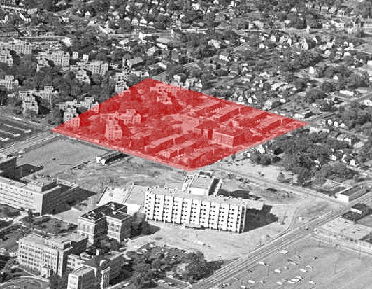 |
Douglass Street: The Douglass Street neighborhood area is bordered by Douglass, New York, Blake, and West Market Streets. The area was dominated by small, tightly packed residences that neighbored industries along the White River, where many residents worked. The neighborhood was dominated by working-class White Hoosiers until the 1920's, and many of their neighbors were Irish immigrants. By 1920, a community of Greeks had moved into the neighborhood as well, fanning out from a slightly earlier Greek community along West Street on the east side of Military Park.
Race by Neighborhood Area, 1880
|
Neighborhood |
White |
Black/Mulatto |
Illegible/blank |
|
Agnes |
127 (83.55%) |
24 (15.78%) |
1 (.65%) |
|
Blackford |
161 (80.90%) |
38 (19.09%) |
0 |
|
California |
245 (89.41%) |
29 (10.57%) |
0 |
|
Douglass |
231 (94.28%) |
14 (5.71%) |
0 |
|
Indiana |
165 (66.80%) |
82 (33.19%) |
0 |
|
North |
46 (38.65%) |
72 (60.49%) |
1 (.84%) |
|
TOTAL |
975 (78.88%) |
259 (20.95%) |
2 (.16%) |
Race by Neighborhood Area, 1900
|
Neighborhood |
White |
Black/Mulatto |
Illegible/blank |
|
Agnes |
253 (96.56%) |
9 (3.43%) |
0 |
|
Blackford |
161 (48.49%) |
171 (51.50%) |
0 |
|
California |
324 (89.50%) |
38 (10.49%) |
0 |
|
Douglass |
335 (96.26%) |
10 (2.87) |
3 (.85%) |
|
Indiana |
106 (52.73%) |
95 (47.26%) |
0 |
|
North |
146 (39.67%) |
222 (60.32%) |
0 |
|
TOTAL |
1325 (70.74%) |
545 (29.09%) |
3 (.16%) |
Race by Neighborhood Area, 1910
|
Neighborhood |
White |
Black/Mulatto |
Illegible/blank |
|
Agnes |
106 (100%) |
0 |
0 |
|
Blackford |
126 (51.63%) |
117 (47.94%) |
1 (.40%) |
|
California |
301 (79.84%) |
73 (19.35%) |
3 (.79%) |
|
Douglass |
567 (97.92%) |
12 (2.07%) |
0 |
|
Indiana |
42 (20.58%) |
161 (78.91%) |
1 (.49%) |
|
North |
141 (38.95%) |
221 (61.04%) |
0 |
|
TOTAL |
1283 (68.53%) |
584 (31.19%) |
5 (.26%) |
Race by Neighborhood Area, 1920
|
Neighborhood |
White |
Black/Mulatto |
Illegible/blank |
|
Agnes |
157 (80.51%) |
38 (19.48%) |
0 |
|
Blackford |
53 (18.53%) |
233 (81.45%) |
0 |
|
California |
344 (59.41%) |
235 (40.58%) |
0 |
|
Douglass |
501 (100%) |
0 |
0 |
|
Indiana |
9 (3.71%) |
233 (96.27%) |
0 |
|
North |
23 (5.89%) |
365 (93.58%) |
2 (.51%) |
|
TOTAL |
1087 (49.56%) |
1104 (50.34%) |
2 (.09%) |
|
|
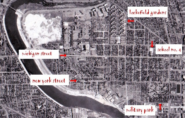
| When this aerial view was taken in 1941, thousands of people lived across what is now the IUPUI campus. The recently completed Lockefield Gardens public housing complex sat near the northern boundaries of campus. School Number 4, where the Mary Cable Building sits today, was at this time still a segregated Black elementary school, and by World War II most campus-area residents were African Americans. |
For comments on or questions about the survey research or the archaeology project, contact Paul Mullins at paulmull@iupui.edu or 317-274-9847.
Last updated October 28, 2003